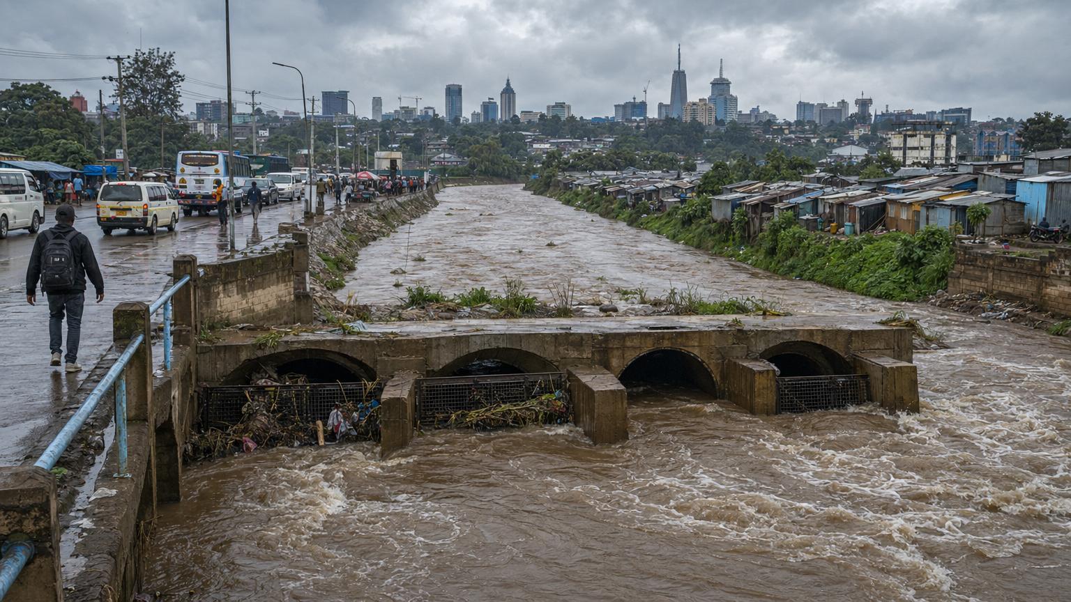
At first, a flood in Nairobi can look like a traffic story. Headlights smear across brown water. Matatus, the city’s quick-moving minibuses, nose through lanes that have stopped behaving like lanes. A pedestrian tests the edge of the road with one careful foot. Someone’s shoe floats by, absurdly calm.
Then the city beneath the city appears. The storm drains. The open channels. The culverts. The river bends. The low places where rainwater gathers because gravity is not impressed by zoning. The places where people live because the city has jobs, land is expensive, and a tin-roofed room near a river can be both a danger and a foothold.
That is why Kenya’s current long-rains season has become more than a run of bad weather. The Kenya Meteorological Department’s heavy-rainfall advisory issued on April 21 warned that rainfall from April 22 to April 27 could intensify over the Coast and parts of the northeastern and southeastern lowlands, with possible floods, flash floods, poor visibility and gusty winds. The advisory expired Monday morning, April 27, but one of its cautions still works like a civic proverb: floodwaters can occur where it has not rained heavily, especially downstream.
Downstream is a physical fact. It is also a political one. Nairobi’s March floods began with rain, but the story did not stop in the clouds. It ran through blocked drains, overwhelmed roads, informal settlements, floodplains, airport delays, hospitals, school closures, demolition plans, legal fights over river corridors and Kenya’s national climate plans. By the end of March, Kenya’s Interior Ministry said floods had affected 30 of the country’s 47 counties, killed 110 people, left three people missing and displaced more than 34,150. The World Health Organization’s Kenya office later put the toll at 112 deaths across 27 counties as of March 30. Disaster numbers often move as counties update reports; the common message is harder to dodge. The water found weak points faster than the city could fix them.
There is no single villain in a Nairobi flood. That is what makes the story useful far beyond Nairobi.
A city can blame a storm. A city can blame litter. A city can blame builders on riparian land, meaning land along rivers and streams that should help absorb, slow or carry floodwater. A city can blame old drainage designs, rushed construction, poverty, climate change, roadworks or people who refuse to move. In truth, flood risk is usually a stack, not a switch. Rain falls on a place that has already made thousands of dry-day decisions about land, housing, pipes, roads, waste, wetlands, budgets and whose warnings count.
Nairobi is not alone. Across East Africa, cities are growing into climates that are becoming less polite. Kenya’s capital now offers a local emergency with a global address: how do fast-growing cities keep water from turning ordinary neighborhoods into evacuation routes?
The rain had a schedule. The city did not.
The March-April-May season is known in Kenya as the long rains. It is supposed to be wet. Farmers, water managers, road crews and city planners watch it closely because it is not only a weather season; it is a planning season.
Kenya’s national seasonal outlook for March through May 2026 forecast near-average to above-average rainfall in several regions, including the Lake Victoria Basin, the highlands on both sides of the Rift Valley, the Rift Valley itself, Nairobi and much of northwestern Kenya. The forecast said April would be the rainfall peak for most regions, while the Coast would likely peak in May. A later onset update said the MAM long-rains onset had already been realized from mid-February in western, central and highland regions, including Nairobi.
That matters because a forecast is not a magic umbrella. A forecast can say rain is likely. It cannot, by itself, clear a drain, move a classroom away from a flood channel, reinforce a bridge, relocate a family with dignity, or tell a commuter whether the underpass ahead is about to become a trap.
When the early March floods hit Nairobi, the first reports were blunt. Reuters reported that flash floods beginning overnight killed at least 23 people, swept away dozens of cars and disrupted flights at Jomo Kenyatta International Airport, the region’s busiest air gateway. Local and international reporting described motorists stranded, vehicles submerged and emergency responders pulled into rescue work. Nairobi County said flooding had exposed drainage bottlenecks and damaged infrastructure across the city’s 17 sub-counties.
By late March, the numbers had grown into a national disaster ledger. The Interior Ministry said Nairobi had recorded the highest number of fatalities, followed by the Eastern region and the Rift Valley. It also listed damaged homes, farms, markets, roads, bridges, water systems, power lines and schools. FEWS NET, the famine early-warning system that tracks food-security and weather conditions, later summarized local reports saying some areas around Nairobi received more than 160 millimeters of rain in 24 hours, enough in places to surpass the average monthly rainfall for March. By late March, FEWS NET said the floods had affected more than 30 counties, displaced more than 34,700 people and caused at least 110 deaths nationwide.
Those figures are terrible. They are also incomplete in the way flood figures are always incomplete. A death toll can count a body recovered from water. It may not count a child’s missing vaccination card, a market trader’s ruined stock, a woman who stops using a latrine because the path to it is unsafe, a family that moves in with relatives and never quite moves back, or a health clinic that spends the next month trying to rebuild ordinary services.
WHO’s Kenya account of the floods began with one such ordinary loss: a mother of five in Gatwekera, in Kibera, returned to find her home submerged and her children’s vaccination records destroyed. That detail sounds small until you imagine the paperwork of survival. In a flood, a document can become a life raft later: proof of vaccination, school enrollment, a clinic record, an identity card, a rental agreement, a mobile-money record. Water is not only wet. It is administrative.
Storm drains are boring until they fail
Drainage is one of the least glamorous forms of public power. A good drain is not supposed to be noticed. It is a public servant made of concrete, gradient and maintenance.
But when drainage fails in a capital city, the consequences travel. Nairobi is Kenya’s political center, a regional business hub and the home of major international institutions, including the United Nations Office at Nairobi. A flood that snarls airport access, blocks major roads or closes schools is not only a neighborhood inconvenience. It can slow freight, aid workers, diplomats, tourists, health supplies and daily labor. It can ripple through a region tied together by roads, ports, remittances, food markets and migration.
Kenya’s own planning documents show that the country understands the stakes. Nairobi City County’s 2023-2027 development plan treats drainage, roads, sanitation, water access and informal-settlement upgrading as core development problems, not side quests. Kenya’s National Climate Change Action Plan for 2023-2027 lists disaster risk management and human settlements among its climate priority areas. Kenya’s second nationally determined contribution, the climate plan countries submit under the Paris Agreement, includes a specific adaptation priority to enhance flood control around informal settlements and flood-prone urban areas.
That last phrase matters. Informal settlements are neighborhoods built outside formal land, planning or building systems. They are not informal because people living there are casual about survival. They are informal because the formal city has not made enough safe, affordable room for them. In Nairobi, settlements such as Mathare, Kibera, Mukuru and others sit close to jobs, roads, markets and rivers. They are often dense, energetic and underserved. They can also be perched exactly where water wants to go.
The World Resources Institute has argued that informal housing needs to be treated as a climate issue, not only as a housing issue. Its recent work highlights places like Mathare, where residents have tried to stabilize riverbanks after flooding, and notes that Kenya’s latest climate planning prioritizes flood control in informal settlements. The lesson is not that poor residents caused the flood. The lesson is that poverty often decides who gets the most dangerous square meter.
One reason this debate becomes heated is that flood safety and housing rights can collide. After major floods, governments often move to clear riparian zones. That can reduce future exposure if it restores river space and removes structures built over drainage channels. It can also create a second disaster if people are evicted without notice, compensation, services or a safe alternative place to live.
Nairobi is in that argument now. In March, Citizen Digital reported that the county was preparing a flood-response plan that would identify drainage bottlenecks, prioritize de-silting and road repairs, and intensify recovery of riparian and floodplain areas under the Nairobi Rivers Commission. Business Daily reported that Kenya’s Environment and Land Court rejected an application by more than 30 property owners seeking to stop government reclamation of riparian land along the Nairobi River. Associated Press reported that a planned demolition linked to the Nairobi River Regeneration Project went wrong on March 16, killing at least four people and injuring four others.
These facts complicate any easy sermon. If a building is sitting in a river’s path, leaving it there can be deadly. If removing it kills people or throws families into deeper insecurity, the cure becomes part of the harm. Good climate adaptation is not only concrete. It is process: warning, consultation, engineering, compensation, relocation, enforcement and patience. Bulldozers are fast. Trust is slow.
The climate signal is real. The explanation still needs care.
It is tempting to write one sentence: climate change caused the Nairobi floods. That sentence is too neat.
A proper climate-attribution study compares the observed event with climate models and historical records to estimate how human-caused warming changed the likelihood or intensity of the rainfall. For the 2026 Nairobi floods, a specific rapid attribution study was not available as of April 27. That means caution is not optional.
But caution does not mean pretending the climate background is blank. The World Meteorological Organization’s State of the Climate in Africa 2024 reported that extreme weather and climate impacts are affecting food security, displacement and development across the continent, and noted that exceptionally heavy 2024 long rains produced severe flooding in Kenya, Tanzania, Burundi and other parts of East Africa. World Weather Attribution’s study of those 2024 East African floods concluded that urban planning, exposure and vulnerability were central to the severity of flood impacts in a warming world. In plain language: heavier rain is a problem; where and how people live can turn that problem into a disaster.
That is the most useful frame for Nairobi in 2026. Climate change can load the atmosphere toward heavier downpours. Regional climate patterns can shift the timing and concentration of rain. But a flood’s harm is also shaped on dry days. Dry-day choices decide whether a wet-day channel is open or clogged, whether a family has a safe floor, whether a bus route has an escape, whether a warning message reaches people who cannot afford to stop working, whether a clinic has backup power, and whether a school can serve as an evacuation center.
ICPAC, the climate center of the Intergovernmental Authority on Development, warned in January that much of the Greater Horn of Africa had an enhanced probability of wetter-than-normal conditions for the March-May season. Its technical statement put above-normal rainfall odds over much of the region, including western Kenya and many surrounding countries. FEWS NET’s April 23 seasonal monitor, however, described a patchwork: an early long-rains onset helped replenish water and soil moisture in some pastoral areas, while heavy rain limited planting in parts of Kenya and dry conditions persisted in parts of Somalia and southeastern Ethiopia.
That unevenness is why national disaster systems matter. A country can be fighting floods in one basin, drought pressure in another and disease risks in both. The April 21 Kenya Met advisory focused on the Coast and parts of the northeastern and southeastern lowlands, not on Nairobi. Still, the capital’s March floods remain the season’s clearest urban warning: rain does not need to be evenly distributed to be nationally disruptive.
A flood is also a health event
The most cinematic part of a flood is moving water. The most dangerous part may arrive after the cameras leave.
Floods can contaminate wells and water pipes. They can push sewage into homes. They can close clinics, damage vaccine cold-chain systems, interrupt medicine delivery and increase the risk of cholera, diarrhea, malaria and skin infections. They can make pregnancy care harder. They can make disability more dangerous. They can turn a trip to the toilet into a security calculation.
WHO’s April 10 report on Kenya’s flood response emphasized damaged water systems, power outages, school closures, impassable roads and disrupted health services. It said several health facilities were inundated and forced to scale down or suspend services, and that Kenya’s Ministry of Health had deployed field teams across 14 counties to support coordination, disease surveillance, infection prevention and water, sanitation and hygiene measures. WHO also said it supplied cholera kits, water treatment supplies and trauma kits.
The New Humanitarian added another layer in an April 20 report on gender-based violence after floods in Kenya’s informal settlements. It described women in places such as Mathare and Baba Dogo facing heightened danger after displacement and loss of shelter. That is not a side issue. A flood changes the map of safety. A path that was merely muddy becomes isolated. A crowded shelter becomes stressful. A lost income stream changes household power. A disaster can reveal old violence by giving it new routes.
This is where the phrase climate resilience can become too tidy. Resilience is not a personality trait that poor people are supposed to keep proving. It is a condition built by systems: drainage that works, waste collection that keeps channels open, bridges that do not fail, health clinics that stay supplied, emergency shelters that protect women and children, land policies that do not punish people for being poor, and budgets that arrive before the rain.
The city has a trash problem. That is not the same as blaming residents.
Anyone who has watched an urban drain during a storm knows that water is a collector. It collects leaves, bottles, plastic bags, scrap metal, cooking oil, mud, lost sandals, branches and whatever the city did not know where to put. A blocked drain can make a moderate storm look like a monster.
So yes, waste matters. Nairobi’s flood debate includes clogged drains, illegal dumping and trash-choked waterways. Ignoring that would be silly. But turning it into a moral story about careless residents is also too easy.
Waste follows service. If a neighborhood has irregular collection, few bins, muddy access lanes, insecure tenure and no reliable drainage, garbage will end up where garbage ends up. If an upstream construction site sends sediment into a channel, a downstream family cannot solve that with better manners. If developers build into floodplains and officials look away, a plastic bottle is not the mastermind.
A fair flood policy has to hold several truths at once. Residents have responsibilities. So do landlords, developers, county governments, road agencies, water companies, national ministries and courts. So do international lenders and climate-finance systems that praise adaptation but often fund it too slowly. Nairobi’s drains are not clogged only with litter. They are clogged with jurisdiction.
The list of agencies involved after the March floods shows the coordination challenge. The Interior Ministry named the Kenya Defence Forces, National Disaster Operations Centre, National Disaster Management Unit, Kenya Red Cross, Kenya Coast Guard, National Police Service, national government administrators, Kenya National Highways Authority, Kenya Urban Roads Authority and county governments among the actors in rescue and relief. That is a lot of logos in one flood.
Coordination can save lives. It can also blur accountability. When everyone is involved, residents may still struggle to know who is responsible for the blocked culvert outside their door.
What would a serious repair list look like?
Start with the boring things. They are usually the radical ones.
First, keep warnings close to people. Kenya’s meteorological service issued seasonal forecasts, monthly outlooks and short-term advisories. The next step is making warnings actionable at street level: which underpasses close first, which footbridges are unsafe, which schools become shelters, which bus routes divert, which clinics have backup supplies, which neighborhoods need door-to-door alerts because a phone message will not reach everyone.
Second, map water like it is a resident. Water has habits. It returns to old paths. Nairobi needs neighborhood-scale flood maps that are public, updated and tied to budgets. A flood map that never changes a procurement plan is just a poster.
Third, protect river space without turning safety into punishment. Clearing riparian buffers can be necessary. But relocation should be planned with affected residents, not performed as a surprise. Compensation, nearby housing options, transport access, schools, clinics and livelihoods are not luxuries. They decide whether relocation reduces risk or simply moves suffering.
Fourth, treat informal settlements as infrastructure priorities. Drainage, sanitation, raised walkways, safe lighting, waste collection, community flood teams and small bridges can save lives before a megaproject breaks ground. The World Economic Forum’s earlier profile of Kibera public-space redesign described residents and city officials working on drainage and vegetation buffers to reduce flood risk. Small does not mean unserious.
Fifth, protect health records and services. Flood response should include mobile clinics, vaccine-record recovery, water treatment, menstrual-health supplies, safe toilets and mental-health support. A family trying to rebuild does not experience health, housing, documents and income as separate sectors. Aid systems often do.
Sixth, finance maintenance. New drainage gets ribbon-cuttings. Maintenance gets mud. Yet the cheapest flood protection may be a crew clearing a channel in February, before April turns it into a brown river.
Why Nairobi matters outside Kenya
Nairobi is a warning, but not in the lazy sense that every city should panic. It is a warning because it shows how climate risk enters through ordinary urban weaknesses.
The global story of flooding is often told with giant numbers: billions in damage, millions displaced, degrees of warming, percentages of rainfall change. Those numbers matter. But the decisive unit of flood risk is often smaller: a culvert, a rental room, a footbridge, a warning text, a clinic shelf, a riverbank, a court order.
World Bank work on flood resilience in fast-growing cities emphasizes that risk assessments, drainage upgrades and natural defenses such as wetlands can reduce exposure when they are planned together. That lesson fits Nairobi, but also Kampala, Dar es Salaam, Lagos, Accra, Colombo, Jakarta, Rio, Houston and Queens. The city names change. The physics does not. Hard surfaces speed water. Poor maintenance blocks it. Wetlands store it. Rivers remember it. Poverty concentrates it.
The politics do change. Some cities have more money. Some have stronger land records. Some have better enforcement. Some have more room to move people safely. Some have less corruption. Some have worse storms. But the core question is shared: can the formal city make space for water before water makes space for itself?
Nairobi’s answer is still being written. Kenya has climate plans, a new disaster-risk management strategy, meteorological capacity, active local media, strong civil society and residents who know their neighborhoods better than any consultant. It also has old drains, fast growth, contested land, fragile housing, floodplain development, limited budgets and a public that has heard promises before.
That mix is not hopeless. It is honest.
The April 21 advisory expired on April 27. The long rains did not sign a peace agreement. The next storm does not need to be historic to be harmful. In a city already wet, already crowded and already arguing over its riverbanks, ordinary rain can find extraordinary consequences.
The best flood policy would make for a terrible action movie. No heroic last-minute rescue. No single villain. No miracle machine. Just drains cleared before the sky opens, river space defended without cruelty, warnings that people can use, clinics that keep working, housing that does not require gambling with water, and budgets that understand maintenance as a form of mercy.
That is the lesson moving through Nairobi’s culverts now. The city is not only trying to survive rain. It is trying to decide what kind of growth can keep its feet dry.