The morning the wall moved
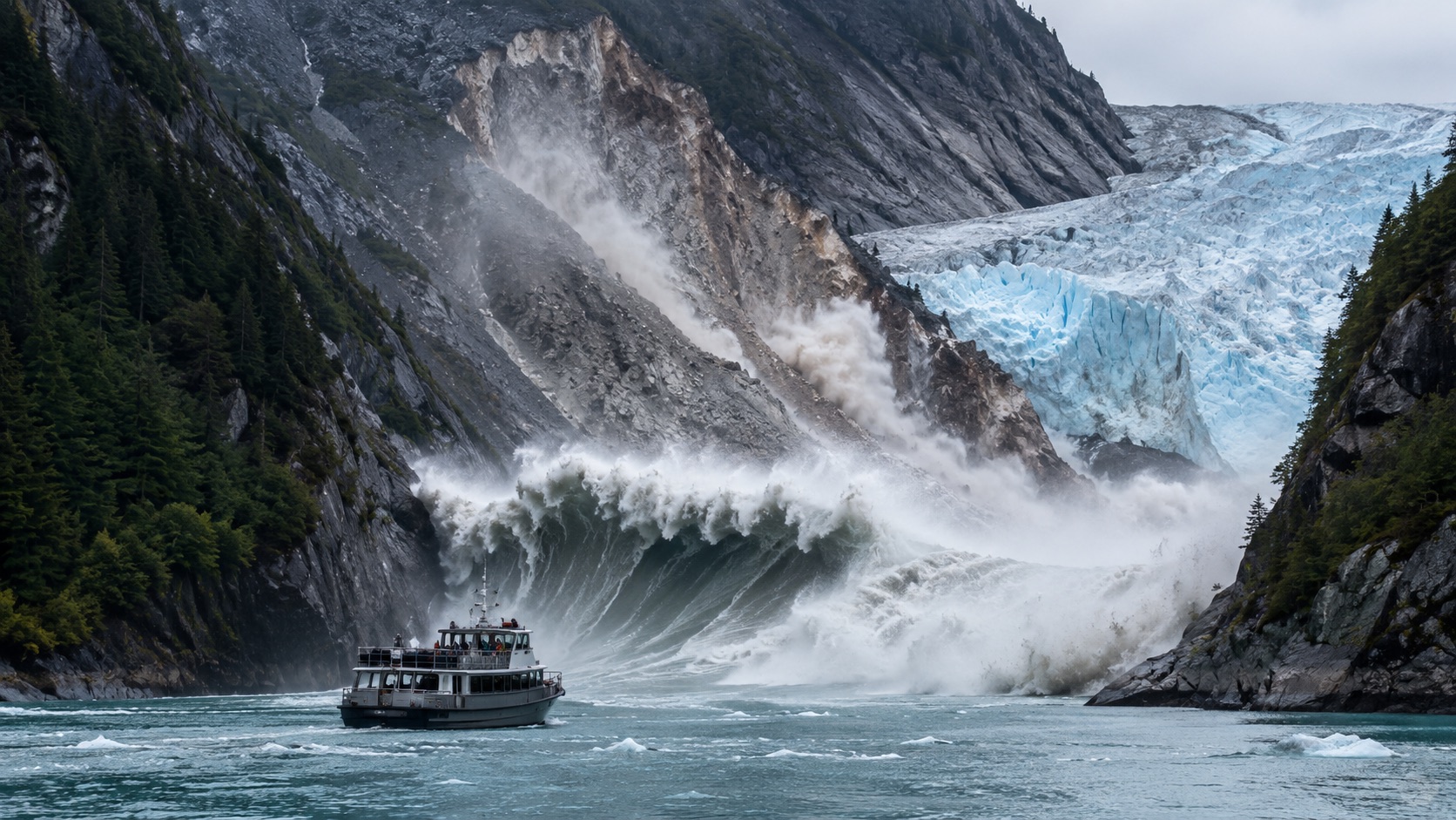
At 5:26 on the morning of August 10, 2025, the head of Tracy Arm stopped being scenery and became machinery.
A mountainside above South Sawyer Glacier failed into a narrow Alaska fjord south of Juneau. Rock and ice came down fast enough to turn water into a weapon, sending a tsunami up the opposite wall and out through a place normally sold as calm wilderness. USGS records place the landslide above the toe of the glacier and report no known deaths or injuries. [2][6]
That last fact is the mercy in the story. It is also the danger. No one died because the fjord was not full yet, because the tourist day had not gathered itself, because no large vessel sat under the slope when gravity arrived.
A warning that depends on the hour of the morning is not a warning system. It is a narrow escape with a timestamp.
Tracy Arm now belongs to a harder category of climate-era risk: places that look timeless until the physical supports behind that beauty begin to move.
A wave with no ocean warning
The public imagination knows the earthquake tsunami: a fault ruptures offshore, the sea floor moves, the wave crosses a basin, and warning centers race a clock measured in minutes or hours.
Tracy Arm was not that story. It was a mountain entering a bathtub, and the bathtub was a fjord with steep sides, deep water, ice, tour traffic, and almost no useful margin for anyone near the source. AAAS described landslide-generated tsunamis as extreme, localized hazards in confined environments. [5][12]
The distinction matters because warnings are not magic. A system designed to model waves crossing open water cannot necessarily save a boat sitting below the slope that fails.
That changes the whole safety question. The task is not only detecting a wave after it starts. It is recognizing dangerous slopes before they throw the wave into motion.
In fjords, the tsunami can come from above. That sentence should be printed in every operations room that sends passengers toward ice.
The number that breaks scale
The headline number is 481 meters. In American terms, that is about 1,578 feet of run-up, meaning the height the water reached on land, not the height of a neat blue wall moving through open sea.
That distinction does not make the number smaller. It makes it more unsettling. The water found the mountain wall and climbed it to a height that makes ordinary disaster vocabulary sound underpowered. UAF reports it as the second-highest slope run-up on record, behind Alaska's 1958 Lituya Bay megatsunami. [3][4]
The event also left damage that was easier to read than the number: stripped vegetation, scoured islands, trimlines on the fjord walls, and the pale signature of water that had gone where water is not supposed to go.
UAF summarized modeling that found a breaking wave roughly 330 feet high moving at more than 150 mph as it struck the opposite shore. That is not spectacle. That is the physics of a confined basin forced to absorb a mountain. [3]
Scale is the part of the story that tempts exaggeration. Tracy Arm does not need exaggeration. The measured landscape is already enough.
The tourist clock had not started
The most important schedule in this story may be the one that had not begun.
Researchers and public reporting describe Tracy Arm as a fjord visited during the summer by tour boats, smaller vessels, and large cruise ships. UAF notes that more than 20 vessels, including ships carrying thousands of passengers, typically move through Tracy and Endicott arms on summer days. AP later reported that several cruise and tour operators shifted 2026 itineraries away from Tracy Arm toward Endicott Arm and Dawes Glacier. [3][7]
This is why the word "remote" can be misleading. Tracy Arm is wild, but it is not empty. Its danger is not just geological. It is logistical: where vessels pause, where excursions gather, how captains receive hazard information, and how quickly a scenic route becomes a trap.
The fjord escaped a mass-casualty event because the collapse happened early and no ships were in the upper fjord. That should not be remembered as proof the system worked.
It should be remembered as the morning the system got a free lesson.
Ice left the room
The cleanest false story would be this: climate change pushed a button and the mountain fell. The more accurate story is less theatrical and more frightening.
Glaciers do not merely decorate fjords. They carve valleys, load slopes, press against rock, and sometimes act like braces in a system that looks still only because humans watch it too briefly. The Science paper and AAAS summary connect the Tracy Arm collapse to long-term glacier retreat and thinning that removed structural support from the slope. [1][5]
UAF reports a critical burst of South Sawyer Glacier retreat in early August 2025, just days before the landslide, leaving a steepened slope without the retaining wall it had previously leaned against. [3]
That is how climate risk often works. It does not always arrive as a single dramatic cause. It rearranges the conditions: less ice where ice held weight, more water where slopes can fail into depth, more traffic where landscapes are changing faster than old assumptions.
The result is not a moral fable. It is a mechanical one. Remove the brace, add time, and the wall may eventually choose its own hour.
The hillside tried to speak
One of the strangest details in the Tracy Arm record is that the mountain may not have failed in silence.
UAF describes preslide seismic activity that began days before the collapse, increased in the final hours, and became a continuous vibration roughly two hours before the slide. The Alaska Earthquake Center's earlier account also noted small magnitude 1 to 2 precursor signals in the hours before failure. [3][6]
This is both hopeful and humbling. Hopeful because the ground sometimes tells on itself. Humbling because hearing a signal after the fact is not the same thing as issuing a useful alert before the wave forms.
Mountains are noisy. Slopes creep, crack, drop stones, settle, and shake. Some warnings are meaningful. Some are background. Some come too late. The scientific problem is to distinguish a slope clearing its throat from a slope announcing catastrophe.
That is not a gadget problem alone. It is a chain of responsibility: instruments, analysts, thresholds, communication protocols, vessel rules, and public trust moving fast enough to matter.
Alaska has a pattern
Tracy Arm feels singular because the number is so large. It is not singular because the mechanism is mysterious.
Alaska already holds the towering comparison: the 1958 Lituya Bay landslide-generated tsunami, the modern record-setter. The state also has the 2015 Taan Fiord event, where a massive landslide near a retreating glacier generated a major tsunami in a remote fjord. Barry Arm in Prince William Sound has been monitored for years because an unstable slope could generate dangerous waves if it enters the water. [8][10][11]
The pattern is not "every fjord is doomed." That would be bad science and worse policy. The pattern is that steep glaciated terrain, retreating ice, deep water, and people in boats deserve the same seriousness we already give to earthquakes and volcanoes.
Rare does not mean unknowable. Remote does not mean irrelevant. Beautiful does not mean still.
Alaska's landscape keeps teaching this lesson at a scale that should make avoidance impossible.
The warning system must move uphill
The phrase "tsunami warning" points most people toward the water. Tracy Arm points the work uphill.
Future safety will need slope inventories, satellite radar, repeat imagery, local seismic tools, bathymetric modeling, vessel exclusion zones, captain protocols, and a habit of making uncertain science operational before a fjord is full of passengers. The Science and AAAS materials both emphasize the possibility, and the difficulty, of learning from precursory signals. [1][5]
That does not mean every crack becomes a closure or every rockfall becomes an alarm. Over-warning can corrode trust. Under-warning can kill. The hard work is to build thresholds that are honest about uncertainty without hiding behind it.
For cruise operators and public agencies, the standard cannot be "the brochure has always worked." A landscape changing under warming conditions needs route decisions that can change too.
The right question is not whether Tracy Arm is beautiful enough to risk. It is whether the system around it is mature enough to say no before beauty becomes exposure.
Luck is not infrastructure
The Tracy Arm megatsunami did not become a mass-casualty story. That is a blessing, not a conclusion.
A mountain collapsed. A wave ran nearly 1,580 feet up a fjord wall. A popular tourist route was transformed in minutes into a source packet for hazard science, cruise planning, and climate adaptation. The public record now says the quiet part clearly: this was a near miss. [4][7]
The purpose of a near miss is not to admire the luck. It is to spend the luck before the next event charges interest.
That means mapping slopes before they fail. It means funding monitoring when nothing dramatic is happening. It means teaching passengers and operators that not every tsunami begins with an offshore earthquake. It means making "not today" a normal safety answer in places where the ground has begun to move.
Alaska's 2025 megatsunami left no death toll. It left something more useful if people are willing to use it: a warning with no funerals attached.
Nobody gets to say there was no warning.
Source notes
Scientific papers, official hazard pages, university summaries, and cruise-route reporting used to check the event timeline, scale, tourism exposure, and monitoring implications.
- Science, A 481 m-high landslide-tsunami in a cruise ship-frequented Alaska fjord. Central peer-reviewed study for the landslide, run-up, seismic, glacier, and modeling claims.
- U.S. Geological Survey, 2025 Tracy Arm Landslide-Generated Tsunami. Used for the event time, location, no-injury report, field observations, preliminary run-up range, and continuing hazard language.
- University of Alaska Fairbanks Geophysical Institute, Study of 2025 Alaska landslide and tsunami contains warnings. Used for the 64-million-cubic-meter estimate, vessel exposure, final run-up context, wave modeling, glacier retreat timing, and seismic precursors.
- University of Washington News, Near miss tsunami in Alaska during tourist season last year highlights increasing environmental instability. Used for the tourist-season near-miss frame and broader environmental-instability context.
- AAAS / EurekAlert, Analysis of 2025 Tracy Arm Fjord megatsunami suggests routes for earlier event detection. Used for the Science publication summary, localized landslide-tsunami hazard framing, glacier-retreat context, seiche description, and detection implications.
- Alaska Earthquake Center, Major Landslide in Southeast Alaska Fjord. Used for early reports, kayaker impacts, initial seismic interpretation, and precursor signal context.
- Associated Press, Cruise companies to Alaska are avoiding a popular excursion to Tracy Arm after a massive landslide. Used for cruise reroutes, Endicott Arm substitutions, and tourism-facing safety implications.
- NASA Earth Observatory, Lituya Bay's Apocalyptic Wave. Used for accessible historical context on the 1958 Lituya Bay megatsunami.
- U.S. Geological Survey Professional Paper, Giant Waves at Lituya Bay, Alaska. Used as the archival technical record for the 1958 benchmark event.
- Scientific Reports, The 2015 landslide and tsunami in Taan Fiord, Alaska. Used for comparison with another glacier-linked Alaska landslide tsunami.
- Alaska Division of Geological and Geophysical Surveys, Barry Arm landslide and tsunami hazard. Used for broader Alaska slope-monitoring and fjord hazard context.
- NOAA / U.S. Tsunami Warning Centers, U.S. Tsunami Warning Centers. Used for official tsunami-warning context and the contrast with fast local landslide tsunamis.
Related reading
Climate • Feature
Your Home Insurance Bill Is the New Climate Map
Wildfire, hurricane, flood, and heat risk are no longer abstract climate charts. They are arriving as premiums, deductibles, cancellations, FAIR Plan growth, and household math.
By Owen Barrett • May 7, 2026 • 9:00 a.m. EDT
Science • Explainer
The Ocean Has a Fever, and the Thermometer Is Everywhere
Ocean heat used to sound distant. Now it is visible in coral bleaching alerts, marine heat waves, sea-level records, fisheries stress, stronger rain, and a global observing system that keeps taking the planet's temperature.
By Mira Sato • May 7, 2026 • 10:10 a.m. EDT

Systems • Deep Dive
The Cold Chain Is the Invisible Machine That Feeds the World
Refrigerated trucks, warehouses, vaccines, fish, fruit, insulin, power bills, refrigerants, and wasted food are all part of one hidden system: the cold chain.
By The Press • May 7, 2026 • 4:00 p.m. EDT