Original Analysis Lab
A front-door index for the reporting and data work built for this story: spreadsheet parsing, derived measurements, source-linked graphics and our own frameworks for judging drone systems.
The drone story is often told around the wrong object. The machine is the easy part: four rotors, a battery, a camera, a radio, a plastic shell, maybe a package hook or a small explosive or a thermal sensor. The harder object is the sky around it.
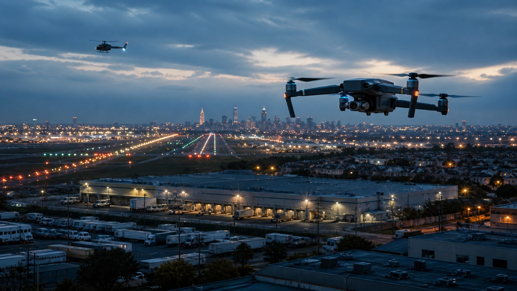
That sky is no longer empty background. It is becoming a live civic system. Hobby drones share it with helicopters. Police departments are building drone-as-first-responder programs. Delivery companies are trying to turn neighborhoods into low-altitude logistics corridors. Airports are filing sighting reports. The military is relearning what mass means when a $500 aircraft can force a $2 million defensive decision. Regulators are trying to move beyond one-off waivers. Congress and federal agencies are deciding whether drones built with Chinese components can keep occupying public-sector fleets. [1] [9] [29] [39]
The simplest way to say it is this: drones have left the gadget era. They are now an infrastructure argument.
This article uses two kinds of evidence. The first is public-record evidence: FAA sighting files, regulatory documents, government forecasts, delivery certification records, civil-liberties analysis, police-program disclosures, military reporting and U.S. supply-chain policy. The second is original analysis by The Press: a structured read of five FAA UAS sighting spreadsheets covering October 2024 through December 2025. That analysis does not create certainty where the source data cannot. It uses the reports as a stress signal. Where official facts end and our conclusions begin, the article says so.
How we read the FAA files
We downloaded the FAA's public UAS sighting spreadsheets for FY2025 Q1 through FY2026 Q1 on May 16, 2026. The files cover reports dated October 1, 2024 through December 30, 2025. We parsed date, state, city and summary fields; counted rows by quarter, month, state and city; extracted reported altitudes from phrases such as "2,500 FEET" and "FL180"; and searched summary text for runway/final, helicopter, law-enforcement notification and evasive-action language. [6] [5] [4] [3] [2]
The limit matters: these are reports, not proven violations. A pilot can mistake an object, a citizen can report a drone that later cannot be located, and a summary can omit details. The pattern is still useful because it shows where the existing airspace system keeps feeling surprised.
The sky is becoming infrastructure
A drone used to be easy to place in the public imagination. It was a toy, a camera, a wedding-video tool, a hobbyist aircraft, a strange buzzing thing above the park. That phase still exists. But it is no longer the center of the story.
The new drone age is built out of permissions, identification, route planning, public trust and fleet operations. FAA forecasts now treat unmanned aircraft and advanced air mobility as a distinct aviation category, with separate projections for recreational aircraft, commercial aircraft, remote pilots and package-delivery operations. The agency expects the commercial fleet to keep growing, and it says remote pilots have become a major part of the aviation workforce. [7] [8]
That matters because a drone flight is not only a flight. It is a claim on space. In a city, that claim can overlap with medevac helicopters, police helicopters, news helicopters, stadium restrictions, airport approach paths, backyard privacy, rooftop cranes, electric wires, schools, wildfire smoke, emergency scenes and thousands of people who did not choose to participate in the mission. In a war zone, the same basic technology overlaps with artillery spotting, electronic warfare, trench assault, naval attack, air-defense economics and supply-chain attrition. In a suburb, it overlaps with the sound of a machine arriving at dinner time with groceries or medicine.
This is why the drone debate becomes confused so quickly. People are not arguing about one thing. They are arguing about five things that share a body: aircraft, sensor, delivery vehicle, police tool and weapon. Regulation tends to separate these categories because agencies need boxes. The public experiences them as one atmosphere.
The conclusion I would stand behind after reading the data and the source record is that the next drone conflict will not be settled by better drones. Better drones are arriving anyway. The bottleneck is institutional. Can the system know who is flying, where, why, under what authority, with what accountability, and with what recourse for people on the ground?
What the FAA files show
The FAA's UAS sighting reports are messy in the way useful public records are often messy. They are not a clean national census of drone behavior. They are a feed of concern. Pilots, towers, law enforcement and other observers see something, tell the system, and the system writes it down. The FAA itself warns that it receives more than 100 reports near airports each month and that unauthorized drone operations can create serious safety risks. [1]
The Press analysis of 2,234 recent rows found a geographically concentrated but nationally distributed pattern. California led the dataset with 289 reports, followed by Florida with 268, Texas with 178, Illinois with 176 and New York with 138. The city field was raw and not geocoded, so it should be treated carefully, but the highest counts still tell a recognizable airspace story: Chicago, New York, Houston, Atlanta, Orlando, Denver, Miami, Washington, Fort Lauderdale, Los Angeles, Phoenix, Charlotte, San Diego, Las Vegas and Boston all appear near the top.
That list is not random. It is hub airspace, tourist airspace, coastal airspace, stadium airspace, law-enforcement airspace and medical-helicopter airspace. The drone is small, but the place it enters is already busy.
The quarter-by-quarter pattern adds another caution. The sighting stream did not rise in a clean line. In the five files we parsed, reports moved from 374 in FY2025 Q1 to 410 in Q2, jumped to 616 in Q3, eased to 531 in Q4, then fell to 303 in FY2026 Q1. That does not prove the sky got safer in the newest quarter. It shows why a single monthly headline is a weak way to understand drone risk. Reporting behavior, weather, travel seasons, enforcement attention, local events and spreadsheet timing can all change the count.
The altitude pattern was more revealing than the city ranking. In the 2,174 reports where altitude language could be extracted, the median was 2,500 feet. That surprised me. The public tends to imagine unsafe drones as low backyard machines or devices skimming airport fences. Those are present. But the reports also describe objects at altitudes that pull them into the world of crewed aviation: 694 reports from 3,001 to 10,000 feet and 166 above 10,000 feet. Some of those reports may be mistaken identity; that is exactly why the data cannot be treated as confirmed drone physics. But from an air-traffic perspective, the uncertainty is part of the problem. If a crew reports a UAS at 8,000 feet, the system has to respond before it has philosophical certainty.
The low-altitude side is just as important. We found 607 reports at or below 1,200 feet. That is where the future drone economy wants to live. Package delivery, inspection work, police first response, search and rescue, news coverage, emergency response and many small commercial missions depend on low-altitude access. The FAA is not just policing a nuisance; it is trying to manage the band of air where the next aviation economy wants to be normal.
The files also show how often drones become a local enforcement problem. Our text search found 1,902 reports with some version of police, sheriff, airport police, state police, law enforcement or LEO notification language. That is a blunt measure, but it captures the operational truth: when an unapproved drone appears near sensitive airspace, the federal aviation system quickly needs a local officer, an airport dispatcher, a sheriff's office or a state-police aviation unit. Airspace governance sounds national. Its first response is often local.
The strict evasive-action count was smaller. Only 14 reports contained positive language such as "evasive action taken" or "pilot took evasive action" after excluding "no evasive action" and "evasive action not taken." That should not be minimized, because one real evasive maneuver is enough to matter. But it also keeps the argument honest. The most common safety issue in the FAA files is not a confirmed collision. It is the repeated appearance of unidentified or unauthorized low-altitude objects inside a system that depends on predictability.
One row in the FY2026 Q1 file shows why the categories are merging. On October 1, 2025, the FAA file logged a UAS incident-accident in Tolleson, Arizona, involving an Amazon MK30 drone striking a stationary crane, causing a post-crash fire and substantial damage, with no reported ground injuries. That was not a hobby sighting. It was the delivery future meeting construction, infrastructure and incident reporting. [2] [19]
My read of the FAA data is not that America is one drone away from panic. It is that the airspace system is repeatedly discovering drones through surprise. Surprise is a bad operating model.
Original analysis lab
Eight calculations that changed our read
These are not official FAA findings. They are The Press's derived measurements from the public spreadsheets, built to separate what the rows can support from what the drone debate often assumes.
Top-five-state share
California, Florida, Texas, Illinois and New York account for 1,049 of 2,234 reports, which makes the pattern concentrated without making it local.
Altitude text recovered
We extracted altitude language from 2,174 of 2,234 rows, giving the altitude analysis a stronger base than the raw city fields.
Low-sky economy
Reports at or below 1,200 feet made up 607 of the altitude-coded rows, the same band delivery, inspection and public-safety operations want to normalize.
Crewed-aircraft uncertainty
Reports above 3,000 feet made up 860 altitude-coded rows, which is why mistaken identity is not a side issue. The uncertainty itself forces response.
Local response load
Law-enforcement notification language appeared in 1,902 rows, showing how quickly a federal airspace concern becomes a local operating task.
Strict evasive-action signal
Only 14 rows used positive evasive-action language after excluding negated phrases. The evidence points more to repeated uncertainty than to constant near-crashes.
Peak-quarter share
FY2025 Q3 alone produced 616 reports, more than a quarter of the five-quarter slice. That looks like a reporting surge more than a smooth adoption curve.
Workflow over maneuver
Runway/final and helicopter language appeared 163 times combined, more than eleven times the strict evasive-action count. The system mostly records disruption before collision.
The measurement problem
The most scientifically dangerous sentence in the drone debate is also the most tempting: "the data shows." Usually it does not, at least not by itself. Drone data is fragmented by design. The FAA has sighting reports, registrations, authorizations, waivers, enforcement records and forecasts. Police departments have flight logs, call categories and retention policies. Companies have route data, noise measurements, maintenance records and crash reports. Defense agencies have procurement numbers and classified performance data. Civil-liberties groups have public-record requests and community complaints. None of these datasets is the drone reality. Each is a window with a frame around it.
That is why this article treats our FAA analysis as a stress test rather than a truth machine. A sighting report is not the same as a verified drone. A low-altitude report near an airport is not the same as a collision risk calculation. A high-altitude report may describe a real unauthorized drone, a balloon, another object, a perception error or a summary that lost context. But the repeated existence of the reports is itself a form of evidence. It tells us where human crews and institutions encounter uncertainty.
For a maturing drone system, uncertainty is not a nuisance variable. It is the core operating problem. A delivery company wants regulators to trust that its aircraft can detect and avoid other traffic. A police department wants residents to trust that it is responding to calls rather than performing general surveillance. A defense agency wants commanders to trust that a small autonomous system will work when the spectrum is contested. An airport wants to know whether an object near final approach is a drone, a bird, a balloon, a reflection or a prank report. The drone itself may be technical. The trust chain is social.
My own working model after reading the records is that drone governance has three layers of measurement. The first is presence: is there an aircraft, and where is it? The second is permission: is that aircraft authorized to be there, right now, for this mission? The third is consequence: what did the flight do to safety, privacy, noise, emergency response, security or public confidence? Most public arguments get stuck at presence. The mature system has to measure all three.
Remote ID helps with the first two layers, but it cannot solve the third. A legally identified drone can still be noisy, unwanted or overused. A police drone can be authorized and still raise surveillance concerns. A delivery route can be safe in aviation terms and still fail a neighborhood consent test. A counter-drone system can identify a threat and still create legal problems if the authority to intercept it is unclear. That is why the best drone policy will look less like a single aviation rule and more like a stack: aviation safety, radio spectrum, cybersecurity, procurement, local land use, public-records law, privacy, emergency management and military readiness.
The rulebook is changing shape
The technical heart of the next drone era is beyond visual line of sight, or BVLOS. Under the older practical model, many drone operations depended on a pilot or visual observer keeping eyes on the aircraft. That makes sense for hobby flying and many site-specific commercial jobs. It does not scale cleanly to package delivery, long linear inspections, public-safety grids, farm monitoring or regional medical logistics. Those missions need aircraft to fly beyond the operator's direct view.
In August 2025, the Department of Transportation and FAA published a proposed BVLOS rule to create a more routine framework for such operations. The proposal would create Part 108, a new regulatory structure for certain unmanned-aircraft operations, replacing some case-by-case exemptions with operating permissions, aircraft requirements and service-provider expectations. [9] [10] [11]
That may sound bureaucratic. It is actually the moment drones become more like infrastructure. A waiver is a permission slip. A rule is a lane.
The FAA has been moving toward that lane for years. Remote ID requires most registered drones to broadcast or otherwise make identification and location information available, which is meant to help authorities connect aircraft in the sky to accountable operators on the ground. The FAA has also been building DiSCVR, a drone-detection and mitigation research tool for airports, while stressing that it is for detection evaluation and does not itself monitor the sky as an enforcement network. [12] [13]
There is also a deeper architecture problem: crewed aviation is built around known aircraft, known routes, known communications and human air-traffic control. Small drones can be cheap, numerous, distributed, semi-autonomous and flown by operators with wildly different training levels. The FAA's unmanned-aircraft traffic-management work imagines a more digital system, where operators and service providers exchange data through APIs instead of every small drone talking to a tower by voice. [14]
That is the right direction, but it creates a public-trust question. If low-altitude operations become a network of private fleet operators, data-service providers, remote pilots and automated approvals, who gets to audit the system when something feels wrong? Who can identify a drone over a school? Who stores the flight logs? Who sees whether a delivery company is overflying the same block 90 times a day? Who can tell the difference between a legal BVLOS delivery route, a police emergency response, a utility inspection, a reckless hobbyist and an aircraft that should not be there?
GAO has repeatedly warned that integration depends not only on aircraft performance but also on identification, counter-drone capabilities, law-enforcement authority, security and privacy. The lesson is plain: the drone age requires governance that is digital enough to scale and public enough to be trusted. [20] [21] [22]
Delivery is a land-use fight
Drone delivery tends to be sold as a speed story: medicine in minutes, groceries without traffic, fewer vans, fewer emissions, more convenience. Some of that is real. The FAA has already approved Part 135 air-carrier operations for drone delivery companies, and the agency says it has completed more than 20 environmental assessments for UAS commercial delivery operations. Zipline, Wing, Amazon and others have all been part of the regulatory path from demonstration to commercial route. [16] [17] [18] [19]
But delivery is not only aviation. It is land use with propellers.
A delivery drone route makes a choice about whose roofline becomes infrastructure, whose neighborhood absorbs the sound, whose yard becomes the emergency contingency zone, whose local government gets complaints, and whose airport or heliport has to coordinate the edge cases. A package does not float through abstract innovation. It crosses someone's block.
That is why the delivery future is likely to be uneven. Medical delivery between fixed sites, rural logistics, island communities, campus routes and urgent light cargo may make public sense sooner than universal burrito delivery in dense neighborhoods. The FAA's BEYOND program has already shown the value of specific operational learning: the agency reported more than 70,000 total flights and more than 48,000 BVLOS flights through that public-private program. [15]
The drone industry often talks about public acceptance. That phrase can become a way of saying the public should catch up. The better version is public consent: a visible map of routes, noise data, complaint systems, local approval, published safety records and clear rules for when a delivery aircraft can fly over private life.
The police drone is a camera with wings
Public-safety drones may be the fastest way many residents encounter the drone age. The drone-as-first-responder model sends an aircraft to a call before officers arrive, giving police a live aerial view of an incident scene. Chula Vista, California, became the signature example, publishing program information and flight data while expanding a model that other departments now study. [26] [27]
The case for the technology is not imaginary. A drone can reach a scene quickly, check whether a weapon is visible, find a missing person, map a crash, watch a fire line, avoid sending an officer blind into danger, and document a situation before rumors harden. For some calls, the drone may lower the risk of a bad human decision because it gives responders more information earlier.
The civil-liberties case is also not imaginary. A police drone is not just a flying radio car. It is a sensor platform that can create a habit of aerial observation. EFF and ACLU have warned that drone-first-responder programs can normalize rapid, low-altitude police surveillance without the warrant logic, public debate or audit systems that should come with such power. [24] [25] [23]
The key distinction is between incident response and atmospheric policing. Incident response says: a call came in, the drone flew to that call, the flight is logged, the recording rules are public, and misuse can be investigated. Atmospheric policing says: the drone is always nearby, the camera can look almost anywhere, and the public learns about the rules only after the program has become normal.
That distinction should be written into policy before the technology gets too convenient. A serious police-drone program should publish flight logs, retention rules, sharing rules, warrant rules, camera-use limits, call categories, error reports and complaint outcomes. It should separate emergency use from patrol use. It should not use "public safety" as a magic phrase that ends the argument. The public may accept drones at fires, active emergencies and missing-person searches while rejecting routine overhead observation. That is not hypocrisy. It is democratic discrimination.
Incident response
Specific call, logged purpose, bounded camera use, retention clock, public category, reviewable complaint path.
Atmospheric policing
General patrol, vague purpose, persistent availability, unclear retention, hidden sharing, no resident-level audit trail.
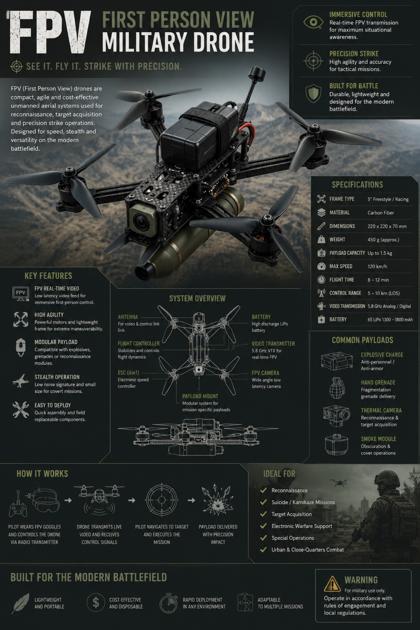
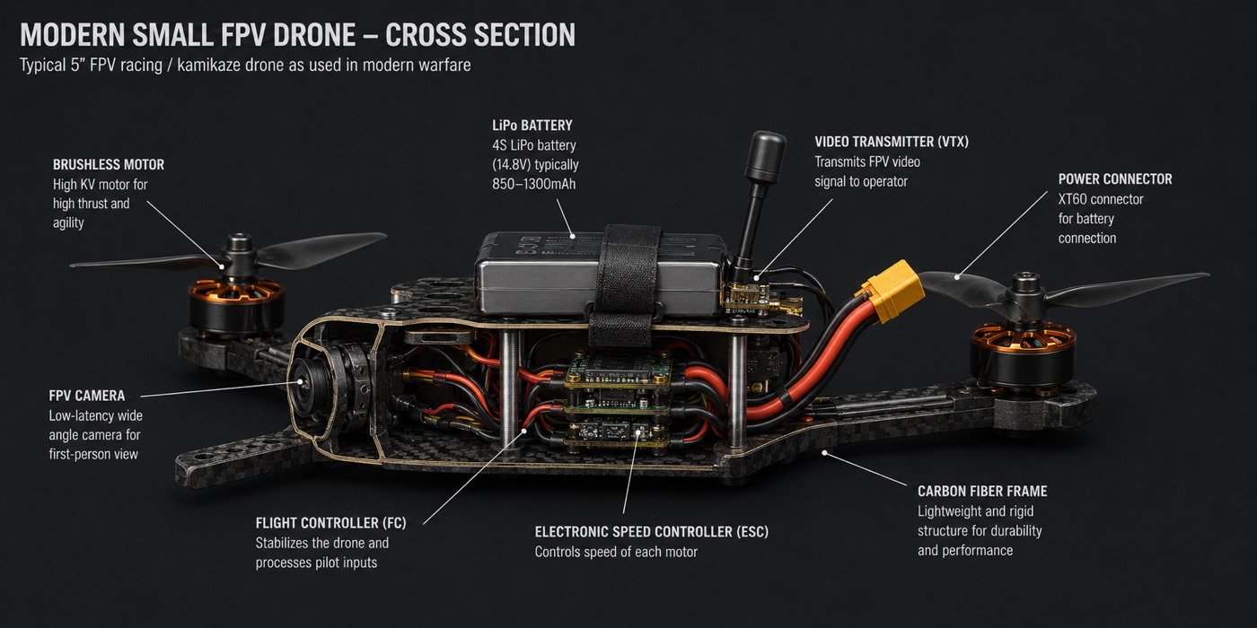
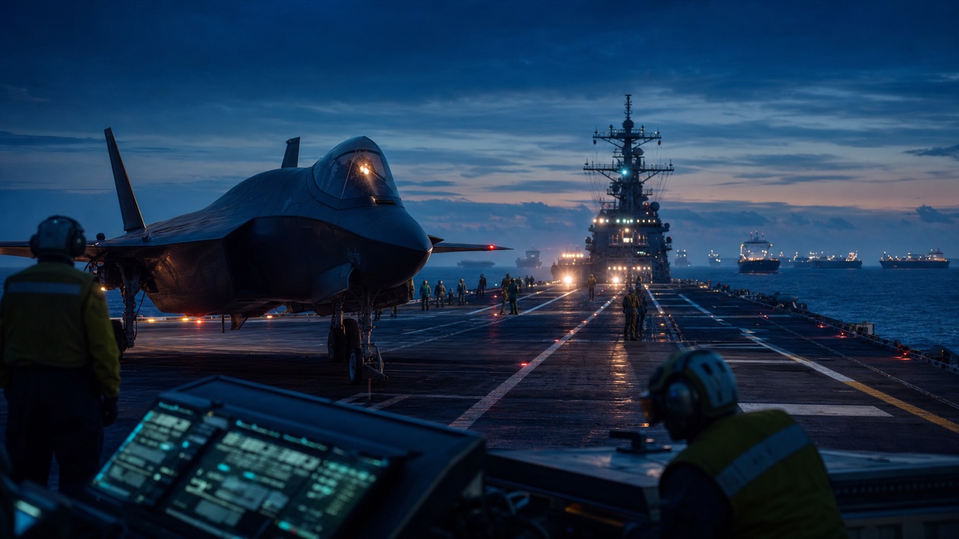
War made the drone consumable
Ukraine changed the drone conversation by making small unmanned aircraft feel strategic. Drones did not replace artillery, armor, infantry, satellites, electronic warfare or air defense. They connected to all of them. They made the battlefield more visible, more lethal, more recorded and more attritable.
RUSI's battlefield work has described a war in which drone, counter-drone, electronic-warfare and artillery systems are tightly linked. CSIS has argued that the United States should learn from Ukraine's commercial-first, fast-iteration drone ecosystem instead of treating drones only as exquisite defense programs. Congressional Research Service work on Replicator tracks the U.S. effort to field large numbers of attritable autonomous systems and the institutional difficulty of doing that inside the traditional acquisition system. [31] [29] [34]
The important shift is economic. A drone can be cheap enough to lose and useful enough to matter. That changes the logic of military procurement. The defense system is comfortable buying platforms that must survive because they are expensive. The drone lesson is that some systems are valuable because they can be risked, updated, replaced and massed.
That does not mean cheap drones are magic. Ukraine also shows the limits: jamming, spoofing, weather, battery life, operator training, component shortages, air-defense adaptation, software updates, spectrum management and the brutal fact that an enemy learns too. A drone advantage can decay quickly if it is not part of a full system.
For civilian readers, the war lesson matters because it pulls the same supply chain and software stack into national security. A camera drone bought for inspection work can share components with a system adapted for war. A communications module, flight controller, battery chemistry or image sensor can become a strategic dependency. Civilian drone policy cannot pretend that drones are only consumer electronics; military policy cannot pretend that drones are only defense hardware.
The hidden airframe is the supply chain
Every drone has a visible airframe and a hidden airframe. The visible one is the body in the sky. The hidden one is batteries, chips, radios, sensors, motors, firmware, cloud services, repair networks, export controls, app stores, procurement rules and spare parts.
The United States has increasingly treated that hidden airframe as a security problem. The American Security Drone Act and related federal acquisition rules restrict procurement of drones and components from covered foreign entities. FCC actions have moved to place foreign-adversary UAS equipment and service providers into the national-security framework that already covers communications equipment. The Commission's late-2025 actions focused on new models and equipment authorization rather than ripping existing devices out of private hands, but the signal was unmistakable: drone supply chains are now communications-security policy. [41] [42] [39] [40]
This creates a hard tradeoff. Chinese firms, especially DJI, helped make high-quality drones cheap and accessible. Many police departments, fire departments, emergency managers, inspectors, journalists, researchers, farmers and hobbyists built muscle memory around those devices. If the U.S. wants a trusted domestic or allied drone industrial base, it has to do more than ban what people already use. It has to make replacements that are affordable, reliable, repairable and available at scale.
That is a manufacturing problem, but it is also a governance problem. A public agency that loses cheap drones may fly less. A small fire department may delay thermal-imaging capability. A farmer may keep older equipment longer. A domestic startup may win procurement but struggle with batteries, chips or component costs. A security rule that looks clean in Washington can become messy on a county budget sheet.
Still, the security concern is not theatrical. A drone sees, stores, transmits and sometimes maps sensitive places. It may fly over critical infrastructure, crime scenes, disaster zones, military facilities or private homes. If its software stack is opaque, if firmware updates are controlled abroad, if data routing is unclear, or if replacement parts depend on a strategic competitor, the aircraft is not just a tool. It is a node.
The conclusion I would stand behind
The strongest conclusion from this reporting is that drones are forcing institutions to govern the space between categories.
They are aircraft, but not like the aircraft the 20th-century aviation system was built around. They are cameras, but not like fixed CCTV. They are delivery vehicles, but not like trucks. They are police tools, but not like radios or patrol cars. They are weapons, but not like missiles or crewed aircraft. They are consumer electronics, but not like phones because phones do not fly into controlled airspace. They are infrastructure, but much of that infrastructure is invisible to the people beneath it.
The FAA sightings we parsed are not proof of a national drone emergency. They are proof of a discovery problem. Too many drone conflicts become visible only when someone sees something unexpected and calls it in. That is a fragile way to run a growing aviation layer.
The regulatory response should focus on three verbs: identify, authorize, audit.
Identify means every serious drone operation should be traceable in real time to an accountable operator, with privacy protections that prevent casual public doxxing but allow lawful safety response. Authorize means BVLOS, delivery, public-safety and inspection missions should move through predictable rules, not endless exception culture. Audit means communities, regulators, airports and courts should be able to examine the records after the fact: where the drone flew, under what authority, what sensor data was collected, how long it was kept, and whether complaints or incidents changed behavior.
The fourth verb is harder: say no. Some drone uses will be valuable. Some will be tolerated. Some will be unsafe, creepy, noisy, strategically reckless or simply not worth the public cost. A mature drone policy will not celebrate every flight as innovation. It will ask whether this flight deserves this sky.
That is the article's central finding. The drone age is not really about drones. It is about whether society can make low-altitude power visible enough to govern.
What to watch next
The next year will show whether the United States can move from scattered drone experiments to an actual operating model. The BVLOS rulemaking will determine how routine long-distance and delivery flights can become. Remote ID enforcement will show whether identification exists on paper or in practice. Police departments will decide whether drone transparency becomes normal or grudging. Defense buyers will decide whether Ukraine's lesson about cheap mass actually changes acquisition. FCC and procurement actions will decide whether supply-chain security creates a real alternative market or only a narrower one.
The public should watch for concrete signals: published route maps, flight logs, noise data, incident reports, enforcement actions, domestic component capacity, police warrant rules, airport detection trials and whether BVLOS approvals become easier to understand from the outside. The drone future will not arrive as one announcement. It will arrive as permissions.
Source notes
- FAA: Drone sightings near airports - Public record index for UAS sighting reports.
- FAA FY2026 Q1 UAS sightings spreadsheet - October 2025 through December 2025 report rows.
- FAA FY2025 Q4 UAS sightings spreadsheet - July 2025 through September 2025 report rows.
- FAA FY2025 Q3 UAS sightings spreadsheet - April 2025 through June 2025 report rows.
- FAA FY2025 Q2 UAS sightings spreadsheet - January 2025 through March 2025 report rows.
- FAA FY2025 Q1 UAS sightings spreadsheet - October 2024 through December 2024 report rows.
- FAA Aerospace Forecast FY2025-2045 - UAS fleet, remote-pilot and package-delivery forecasts.
- FAA UAS and Advanced Air Mobility compendium - FAA forecast detail for unmanned and advanced-air-mobility markets.
- FAA: Beyond Visual Line of Sight - Agency summary of BVLOS proposed rulemaking.
- U.S. DOT: Proposed rule to accelerate safe drone operations - Department announcement of the BVLOS framework.
- Regulations.gov docket FAA-2025-1908 - BVLOS rulemaking docket.
- FAA: Remote ID - Identification requirements for drones.
- FAA: DiSCVR drone-detection research tool - FAA airport detection and mitigation research context.
- FAA: UAS Traffic Management - Digital traffic-management architecture for small UAS operations.
- FAA: BEYOND program - Public-private BVLOS and UAS integration program statistics.
- FAA: Package delivery by drone - Part 135 air-carrier certification and commercial delivery background.
- FAA: Zipline BVLOS package-delivery authorization - Drone delivery authorization context.
- FAA: Wing DFW Supplemental Environmental Assessment - Delivery environmental-review record.
- FAA: Amazon Prime Air Tolleson environmental assessment - Site and operations context for Amazon delivery drones.
- GAO: FAA should improve its Remote ID implementation - Oversight report on drone identification implementation.
- GAO: FAA needs a strategic drone integration approach - Oversight context for national airspace integration.
- GAO: Counter-drone technologies - Detection and mitigation oversight context.
- GAO: Drones, privacy and federal laws - Legal and privacy background.
- EFF: Drone as First Responder programs, 2025 review - Civil-liberties analysis of DFR expansion.
- ACLU: Protecting privacy from aerial surveillance - Privacy recommendations for government drone use.
- Chula Vista Police Department UAS program - Public program description and transparency context.
- CNA: Drones as First Responders - Public-safety drone-program analysis.
- U.S. Justice Department: Unmanned Aircraft Systems - Federal law-enforcement UAS policy context.
- CSIS: What the U.S. can learn from Ukraine's drones - Military drone production and adaptation analysis.
- CNAS: Lessons in learning - Military autonomy, adaptation and learning context.
- RUSI: Emergent approaches to combined arms manoeuvre in Ukraine - Battlefield drone, EW and fires context.
- RUSI: Silicon lifeline - Electronics supply-chain evidence in modern war.
- RUSI: Sea drones at war - Maritime uncrewed-system analysis.
- Congressional Research Service: Replicator initiative - U.S. military attritable-systems procurement context.
- Defense Department: First tranche for Replicator - Official Replicator capability announcement.
- DOD Inspector General: Replicator evaluation - Oversight of the Replicator initiative.
- Defense Innovation Board: Pathways to scale - Defense acquisition and scaling recommendations.
- White House: Unleashing American Drone Dominance - Executive action on U.S. drone policy and production.
- FCC fact sheet: Covered List proceedings for UAS - UAS equipment authorization and national-security context.
- FCC Public Notice DA-25-1086 - Foreign UAS covered-list notice and exemption context.
- Federal Acquisition Regulation 52.225-33 - American Security Drone Act procurement representation.
- SAM.gov: American Security Drone Act covered foreign entities - Federal procurement list context.
- FAA: LAANC - Low Altitude Authorization and Notification Capability context.
- FAA: B4UFLY - Public safety and flight-awareness tool context.
- FAA: Public safety and government drone operations - Government UAS operations context.
- NTSB aviation accident reports - Accident-investigation background for aviation incidents.
- EASA: Drones and air mobility - European drone regulatory context.
- UK Civil Aviation Authority: Drones - UK drone rules and public guidance.
- FAA: Certificated remote pilots including commercial operators - Part 107 operating and certification context.
- eCFR: 14 CFR Part 107 - Federal small UAS operating rules.
- eCFR: 14 CFR Part 89 - Remote identification rule text.
- FAA: Register your drone - Drone registration requirements and public guidance.
- FAA DroneZone - FAA registration and authorization portal.
- FAA: Recreational flyers - Hobbyist drone rules and safety guidance.
- FAA: The Recreational UAS Safety Test - TRUST test and recreational-flyer knowledge requirements.
- FAA: Where can I fly? - Restricted-location and airspace public guidance.
- FAA: UAS facility maps - Airport airspace authorization maps for drone operators.
- FAA: Part 107 waivers - Case-by-case waiver framework that BVLOS rulemaking could reduce.
- FAA: Advanced drone operations - Package delivery, BVLOS and other advanced operation context.
- FAA: UAS test sites - Research and integration test-site network.
- FAA: UAS Integration Pilot Program - Completed public-private drone-integration program.
- FAA Aeronautical Information Manual: UAS operations - Pilot-facing airspace guidance for UAS.
- FAA: Where recreational flyers can fly - FAA public guidance on legal recreational drone locations.
- Federal Register: Remote Identification of Unmanned Aircraft - Final rule background for Remote ID.
- Federal Register: Operation of small UAS over people - Final rule for operations over people and at night.
- FAA Advisory Circular 107-2A - Guidance for Part 107 small UAS operations.
- FAA Advisory Circular 91-57C - Recreational UAS operations guidance.
- FAA UAS Data Delivery Service - Open-data portal for UAS maps and services.
- DOT privacy impact assessment: LAANC and B4UFLY - Privacy context for drone authorization and awareness tools.
- NASA: UTM Technical Capability Level 2 report - Field-test background for UAS traffic-management research.
- NASA: UAS Traffic Management project - Program context for UTM pilot and field-test work.
- FAA: UTM Pilot Program Phase 2 progress report - Technical progress report on UTM demonstrations.
- FAA: Remote ID - Operator-facing compliance and identification guidance.
- NASA: UAS Traffic Management - NASA research program for low-altitude drone traffic management.
- NASA: What is UAS Traffic Management? - Plain-language UTM architecture overview.
- NASA: UTM TCL2 technical report - BVLOS-focused traffic-management research campaign.
- NASA Technical Reports Server: UTM search - Technical reports for UAS traffic-management research.
- NASA Technical Reports Server: TCL2 report - NASA report on UTM technical capability level work.
- NASA: TCL3 flight test report - UTM flight-test findings and architecture context.
- NIST: Aerial systems standard test methods - Public-safety drone test-method development.
- NIST: Aerial response-robot tests - First-responder drone performance testing context.
- DHS Science and Technology: Counter-UAS - Federal counter-drone research and testing context.
- CISA: Unmanned Aircraft Systems - Public-safety, security and infrastructure drone context.
- NIST: Aerial systems test methods - Public-safety drone testing context.
- DHS: Counter-UAS - Federal drone detection and mitigation testing context.
- CISA: UAS physical security topic page - Critical-infrastructure awareness guidance for drones.
- CISA: UAS and infrastructure security - Security guidance for infrastructure owners.
- DHS: Counter-UAS legal and technical context - Counter-drone detection and mitigation background.
- Justice Department: Unmanned Aircraft Systems - DOJ context for UAS policy and authorities.
- Justice Department: UAS policy resources - Public-safety and legal context for drone use.
- GAO: Drones, privacy and federal law - Federal legal background for government drone use.
- CNA: Drones as First Responders - Public-safety drone program lessons.
- Chula Vista: Drone as First Responder launch - Local launch record for the signature DFR program.
- Chula Vista: UAS flight data - Local transparency and flight-data record.
- Chula Vista Police Department: UAS program - Local case-study context for drone-first-responder operations.
- ACLU: Drones for them but not for us - Civil-liberties analysis of unequal drone-surveillance rules.
- ACLU: Curbs needed on police drone surveillance - Policy concerns around drones at public gatherings.
- EFF: Atlas of Surveillance - Database context for local surveillance technologies.
- EFF: Drone First Responder programs review - Civil-liberties background on police drone deployment.
- Congress: Drone privacy legislation - Federal legislative context for privacy limits.
- EASA: Drones and UAS FAQ - European drone regulatory framework.
- EASA: Drone operation categories FAQ - European low-risk drone operation rules.
- ICAO: Unmanned aviation - International civil-aviation context for unmanned aircraft.
- EASA: Specific category and risk assessment context - European risk-assessment background for drone operations.
- EASA: UAS regulatory FAQ - European air-traffic and drone integration context.
- SESAR: U-space - European research and deployment framework for drone services.
- UK CAA: Beyond visual line of sight operations - UK BVLOS innovation and approval context.
- Wing: Drone delivery - Company background on commercial drone delivery operations.
- Wing: Drone delivery - Local delivery-market and service context.
- Zipline: Home - Drone logistics and delivery-platform context.
- Amazon: Prime Air news - Company updates on Amazon drone delivery.
- Walmart: Drone delivery expansion to new cities - Retail delivery expansion context.
- Defense Innovation Unit: Blue UAS - Trusted drone procurement program context.
- DIU: Blue UAS cleared list - Cleared UAS list for government users.
- DIU: Blue UAS framework - Framework for trusted UAS acquisition.
- AUVSI: Green UAS - Industry pathway for cybersecurity and supply-chain review.
- Federal Register: ICTS supply-chain rulemaking for unmanned aircraft - Commerce Department supply-chain security context.
- BIS: Connected vehicle ICTS rulemaking reference - Related Commerce Department connected-technology security context.
- Defense Department: Replicator on track - Defense innovation update on attritable systems.
- Defense Department: Replicator on track - Official update on autonomous-system fielding.
- U.S. Army: Air launched effects for Future Vertical Lift - Military uncrewed teaming and launched-effects context.
- RAND: Drone warfare research - Defense-research context for military drone adaptation.
- CNAS: Drone proliferation - Policy analysis of autonomous and uncrewed systems.
- Congressional Research Service: Military UAS - U.S. military unmanned aircraft systems background.
- CSBA: Advanced unmanned systems and AI for naval superiority - Defense strategy analysis for uncrewed systems.
Related reading
Technology • Analysis
The Battery Is Becoming the Grid
Grid batteries, electric cars, lithium supply chains, virtual power plants, and interconnection queues are turning storage from a gadget story into the shock absorber of the power system.
By Julian Mercado • May 7, 2026 • 11:20 a.m. EDT
World • Analysis
America's Military Year Is a Map of Force
From the Maduro raid to the Iran war, Hormuz, cartel boat strikes, classified AI and the defense factory floor, 2026 shows how U.S. power now moves through operations, logistics and production.
By Samir Haddad • May 8, 2026 • 11:00 a.m. EDT
Technology • Report
AI Needs Electricity, Steel, and Time
Behind the chatbot boom is a slower race over transformers, substations, fabs, and the people who know how to build them.
By Julian Mercado • April 6, 2026 • 9:05 a.m. EDT


